A DRAFT HISTORY OF ROSELAND LAKE
(THIS PAGE IS UNDER DEVELOPMENT and should not be quoted)
NAMES
Roseland Lake was not always called Roseland Lake. Over time, it was referred to by various names on maps, deeds 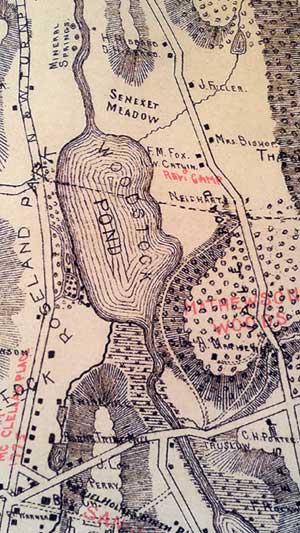 and other documents, including the following. Ponds and rivers were important landmarks for travellers and the first settlers of Woodstock.
- Great Pond
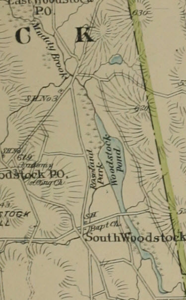
- Woodstock Pond (e.g., on 1856 map of Windham and E.M Woodford map of 1856, 1859 Topo map of State of CT by Clark & Tackabury, 1869 map of Windham County by Ormondo Gray, 1883 Lester map of Woodstock, and the 1888 USGS Topographical Map, Quadrangle 20, Putnam, 1893 Town and City Atlas of the State of CT)
- Woodstock Lake (e.g., 1833 New London and Windham Counties William Lester Jr. map, map of New London and Windham Counties, 1886)
- Senexet Pond (Note: on some maps [e.g., the 1883 Lester map] the area to the north of the lake is shown as Senexet Meadow. Senexet (Valley or Meadow) in Windham County was Nipmuck for"rock-strewn fields" or "gravelly place" or "place of small stones." [Nipmuc Place Names of New England]
- Roseland Pond
- Roseland Lake (used after 1876)
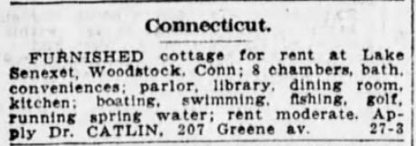
- Lake Senexet (in 1909, and in a newspaper ad from 1920 for a cottage rental and on The Lakeside Vacation Home flyer.)
- Roseland Lake (again, today)
- Did it have a Native American name? (Note: Wappaquasset Pond is a different body of water.)
- (Note: Bowen's history of Woodstock, p. 27, refers to a property "near the falls below Muddy Brook Pond, as Woodstock Lake was called" but there is a separate body of water in Woodstock now referred to as Muddy Pond.)
Roseland Lake is located in South Woodstock. This area was referred to as"The Eastward Vale" by the original white settlers of Woodstock. [Journey Through Woodstock]
Muddy Brook was probably named because "the vigorous action of the stream upon its banks makes the water sometimes of dusky hue" (per A Modern History of Windham County, p.832)
NATIVE AMERICAN PRESENCE
Before the settlers arrived in 1686, the area we now call Woodstock was within the Nipmuck/Nipmuc tribal territory. The Nipmuck descended from the Algonquian peoples of Nippenet. (Were they also called the Wabbaquassets?)
The area west of the Quinebaug River was known to the Nipmuck as part of Wabbaquasset (variously spelled Wabaquasset, Wabaquassit, Wabaquassuck, Wapaquasset, and Wabquisset) meaning "mat producing country." This term refers to the marshland rushes (cattails?) and reeds used to make mats to cover a lodge.
At the time the settlers came, Wabaquasset country was held by the Mohegan Uncas as a Pequot conquest. [Early Homesteads of Pomfret and Hampton] Wabaquasset country was formally deeded to Captain James Fitch in 1680. [History of Windham County, p.29]
Praying Indians Village
The Puritan missionary John Eliot encouraged the Native Americans to consolidate in planned towns. Eliot called the Indian Village of "Praying Indians" in South Woodstock Wahbuquoshish. It was described as being "near the bend in the outlet from Woodstock Pond.""Great quantities of arrow and spear heads and other implements have been found..." there. [A Modern History of Windham County, Connecticut] Is this the Basto site by Chace Lumber? In 1934, Arthur Basto, an amateur archeologist, confirmed that this village was located near Woodstock Pond, on the site of the William Basto Farm.
TRAILS
The Old Connecticut Path
The Old Connecticut Path runs "a little north of Woodstock Pond" [History of Windham County] This trail went by other names: the "way to Woodstock," the "King's Highway," the "old Nipmuck Path," "Mishimmayagat" or the "Indian Trail. "It was a "great path - thoroughfare of the moccasined red man" [Harral Ayers, The Great Trail of New England, 1940], leading "from Woodstock Pond, in the heart of Woodstock, to Black Pond and then onward to Hatchet Pond....." [A Modern History of Windham County, Connecticut]
A road used to circle most of Roseland Lake. Journey Through Woodstock includes a photo of girls from a local summer camp on a hayride around the pond. Remnants of the road are visible on the 1934 aerial photographs.
There was apparently "a wide gravel path that leads down a small hill." (Is this referring to Mount Eliot in Roseland Park?) "A physical fitness trail with designated exercise stops, the dirt road 1.3 mile loop Woodstock Pond Trail encircles the Pond. It connects with the 2.6 mile round-trip Backbone Trail, the park's main route through forest and open meadows." It had stretching stations, bars and other devices. [Modern History of Windham County]
ROADS TODAY
The roads around Roseland Lake are:
- Roseland Park Road to the west (formerly known as New Turnpike)
- Stonebridge Road to the south.
- And old cart path/dirt road called "Dunleavy Road" that exits off of Stonebridge Road and runs along part of the southeastern shore of the lake.
- Senexet Road (or Senexet Road No.1) to the east and north.
TERRAIN AND VEGETATION
Back in the late 1800s, the land surrounding Roseland Lake was marshy woods, with lots of oak trees. Lofty 'Cathedral' pines were found on the eastern shore. [A Modern History of Windham County] A 1934 visitor described "approaching Senexet [House] through tall pines, dark against the sunset, with yellow beech leaves glowing between the branches. [The Christian Register] The hurricane of 1938 toppled many of those tall pines. [Journey Through Woodstock] Some of the upturned stumps are still visible.
Watch a brief sideshow of aerial photography, showing land use changes from 1934 - 2014.
FARMING
In addition to hunting and fishing, Native Americans grew corn in Wabaquasset. Great sacks of corn were carried on the backs of the Wabaquasset Indian, Acquittimaug, and others, to Boston for food 1630. It is believed that this corn was grown on the grounds of what was later the William Basto Farm. [Early Homesteads of Pomfret and Hampton, p.6]
Arthur Mathewson had a farm by Roseland Lake. The land now occupied by Roseland Park used to be part of the Mathewson Farm? The "Mathewson Woods" shown on the 1883 Lester map contained the Cathedral Pines.
Attempts to utilize small streams like Muddy Brook for manufacturing were not successful, as it was too small. [History of Windham County]
A number of active farms and cropland are still located upstream of the lake.
ROSELAND PARK
Henry Chandler Bowen (1813-1896) purchased a wood-lot and pasture on the west side of "The Great Pond" from William Williams Mathewson (1829-1901.) [Lineage of the Bowens in Woodstock, CT] Bowen planned to turn this wildland into a "pleasure grounds."
Bowen was a Woodstock native who became an influential New York merchant, newspaper publisher and abolitionist. He summered at Roseland Cottage (also known as "The Pink House" which was commissioned in 1845) According to family stories, Roseland Cottage was named after the family’s favorite flower, the rose. [SPNEA FAQs] Three decades later, he also dubbed the Park "Roseland."
Roseland Park was a "delightful grove" set on approximately 60.3 acres on the shores of Roseland Lake. Bowen spent a decade grading and planting the land. He had laborers move sand and gravel (90,000 loads of glacial till) from nearby hills to re-shape the shoreline and build up the swampy land. During slow periods, local farmers like Marcus Johnson's grandfather helped with the hauling.
The project included a mile-long retaining wall that extends from the south end of the park to the northern inlet where Muddy Brook feeds the lake. [Journey Through Woodstock] Perhaps for this reason, some sources refer to Roseland Lake as "man-made." Although the shores may have been modified, the lake is natural, and appears on the earliest maps.
According to Journey Through Woodstock, "the "golden age" of Roseland Park lasted 20 years, from its dedication, July 4, 1876, to the death of Henry Bowen in 1896. Activities at the park included fireworks, boat rides, picnics, concerts, school and Union Sabbath School celebrations for people throughout Windham County, political mass meetings, the artist James Sawyer painting sitters, and strolls along the wide paths of Mount Eliot." (Mount Eliot is a hilly knoll in the park.)
Back in the day, the Victorian-style park sported a beautiful arched entrance gate, a hitching ground that could accommodate 1,200 wagons and teams, a boat house with a piazza (veranda), an ice house, a pier with diving boards and a little gazebo on the end, private bungalows, a windmill, gilded fountains, decorative statues, roads, walks, lawns, and tree and flower beds in fancy shapes full of perennials and over 1,000 rosebushes. [Journey through Woodstock] Paddle boats, Jon boats, canoes and kayaks could be rented for use on Woodstock Pond. [Modern History of Windham County]
Fourth of July celebrations at the Park attracted as many as 10,000 people. Attendees listened to speeches, watched fireworks and drank pink lemonade. "National celebrities in innumerable departments, presidents, cabinet officers, senators, governors, statesmen, financiers, distinguished professors and teachers, orators, lecturers, poets, literary men and women, clergymen without number, representative men and women, have appeared upon the platform at Roseland Park and discoursed upon questions of vital interest and importance. " [History of Windham County, Connecticut, p.905]
Notable guests included Oliver Wendell Holmes (1877, which the History of Woodstock lists as the first year the park was open to the public), President Rutherford B. Hayes (1883), President Benjamin Harrison (1889) and Governor (and later President) William McKinley (1891.) (Note: President Ulysses S. Grant was at Roseland Cottage on July 4, 1870, before the park opened.) [Journey Through Woodstock and History of Woodstock]
In Bowen's will, the park was donated to the people of Woodstock and surrounding towns, and is operated today by the Trustees of the Bowen Family Trust. Alas, few of the Victorian features remain, and the roses are long gone.
OTHER HISTORICAL STRUCTURES
In addition to Roseland Park, a number of farms, summer cottages and structures dotted the shores of Roseland Lake as far back as the mid-1800's. "The summer element is conspicuous in many new and elegant country seats in various parts of the town. Senexet road, running east of the lake, is especially favored by these summer sojourners, and boasts many of these fanciful structures." [History of Windham County, p.904]
 Around 1886-1897, Horace E. Deming (1850-1930), a prominent New York Lawyer, and his wife Caroline (nee Springsteed) set up a summer cottage off of Senexet Road called "Nipnet." As a child, Frances Parkinson Keyes (1885-1970) visited Nipnet, and wrote about her visits in her autobiography Roses in December.
In 1932, Mrs. Theodore Chickering Williams, widow of a Unitarian minister, visited the house, which had been vacant for 14 years. She was "struck the serene beauty of the place, as well as its location between Hartford and Boston" and decided it would be perfect for a retreat center. A group of Unitarian lay persons raised funds and formed The Retreat, Inc., which now owns the Senexet House. [Senexet House papers; Senexet House: A Brief History, Rev. Cornelius Bakker]
In date?, Arthur Basto family brought a "healing stone" to the Senexet House. The stone had originally been in another nearby location.
The "Lakeside Vacation Home" on "Quasset Brook Farm" Roseland Park Road still stands. It was a summer resort - see flyer. (in the area that is now Cornfield Point condos) In 1909, it rented for $2.50/day (or $8-15/week), accommodating 30 to 40 guests "on a farm with fields, extending down to the shore of Lake Senexet...surrounded with pleasant lawns, well shaded by fine old trees. It is supplied by excellent water piped from a spring on the hillside....next to Roseland Park and Woodstock Country Club (also called the Woodstock Golf Club). Complete with a romping room! Activities listed as: tennis, badminton, quoits, croquet courts on lawns, golf (minimum fee), sailing, boating, fishing, swimming in lake or a cool refreshing dip in bubbling brook, hiking horseback riding along scenic bridle paths. Band concerts each week." For particulars, people could contact Mrs. S.A. Clarke.
Bonie Doon was the summer home of Dr. John Evans Sheppard (1859-1915), an ear specialist, his wife Jane Argyle Campbell Sheppard and their daughter Ruth. It was located "east of the Stone Bridge." Rear Admiral John G. Walker owned the house before the Sheppards, and called it Interlaken. Later the house was known as the Stone Bridge Inn, when it was a camp for boys. (See 1918 photo in Journey Through Woodstock.) The Inn was destroyed in a fire.
The Stone Bridge (on Stone Bridge Road) was built "where Somers Turnpike crossed the Little River between Roseland and Little Ponds." [Journey Through Woodstock]
Roseland Lake drains under Stone Bridge Road into Sheppards Pond, which is named after the Sheppard's who lived to the south of Roseland Lake. The name of the smaller body of water is variously misspelled as Shepard's Pond, Shepherd's and Shepherds Pond (e.g., on a 1955 Topo map). According to Journey through Woodstock, the first settlers referred to it as "Little Pond. The road to the west of it is now called Little Pond."
Rev. Camp is shown on the 1883 map. It was located in the house on 322 Senexet Road.
Pomfret School had a camp on the northeast side of the lake at what is now 340 Senexet Road.
The 1883 Lester map shows "Mineral Springs" near Deacon Abel Child's house, on the other side New Turnpike Road (now Roseland Park Road.) According to the History of Windham County, the springs enjoyed "wide popularity for a season." (More about the "Mineral Springs" to come.)
PUTNAM'S WATER USE
According to the History of Windham County, Connecticut, one of the most important works accomplished in Putnam, CT was the introduction of an abundant supply of water from Roseland Lake. "Damage by fire and much household inconvenience had accrued from previous scarcity. Mr. George E. Shaw was the first to agitate the matter, laying before the association, in 1884. a resolution to investigate the feasibility of introducing water into Putnam village. ...they petitioned the legislature for incorporation, and formed a joint stock company.... Wheeler & Parks, of Boston, selected-they agreeing to furnish the Putnam fire district with sixty hydrants, at the cost of $1,800 annually. A supply of water was obtained from the outlet of Woodstock lake, about two miles distant, and brought into a receiving tower on Oak hill, and thence distributed throughout the village. A million gallons -daily could be used. ... The work was completed January 21st, 1886."
The Putnam Water Control Authority still relies heavily on water drawn from Roseland Lake, under a permit with the CT DEEP.
FISHING
Fishing has long been popular on Roseland lake. In 1920, Hamilton Holt (Henry Bowen's great grandson) said "I once caught a bass weighing over five pounds just off the inlet, and have caught many in the lake over three pounds." [The Independent, 1920 article, quoted in A Journey Through Woodstock] Read more about fishing on the lake.
BATHING
The public swam in Roseland Lake until the 1960s or the early 1970s? [date?] Many Woodstock residents took swimming lessons off the dock at Roseland Park. (The dock fell into disrepair, and in 2005 the gazebo floated away in a flood. The dock was rebuilt and a gazebo added in 2015.)
The Johnson family even put cobblestones down on the lake floor in the northern cove (which is now Zeelandia) to make it more pleasant for bathing.
Benjamin Shapiro of Woodstock made the news as one of three bathers "nolled" (fined?) on July 28, 1924 for swimming in the lake "contrary to notices posted by order of the State Health Board." [Bridgeport Telegram, 29 July 1924, p.10]
A special watershed inspection by the State Dept. of Health noted that"Pollution of Roseland Lake, Roseland Park, by bathing and boating was investigated, and the Health Officer was advised that the practice was considered detrimental to health. In view of the fact that the city was preparing to install a chlorinator, orders forbidding these sports were not recommended." [State Department of Health, Thirty-Seventh Report for two years ending June 30, 1922]
The Town Clerk of Woodstock provided this language from the land records Vol.41 Page 558: Trustees of Roseland Park et all [??] Harold S. Deming For one dollar, the receipt whereof is hereby acknowledged by [not legible] for other valuable considerations, we the undersigned, owners of land bordering on Woodstock Lake, hereby agree that we will not attempt, directly or indirectly, to prevent one another from continuing to enjoy the rights of bathing, boating and fishing in Woodstock Lake, and that this agreement shall be binding on our successors, heirs and assigns, and shall be recorded in the office of the Town Clerk of Woodstock, Connecticut Woodstock Connecticut The Trustees of Roseland Park (seal) Edward [A.?] Bowen President of the Trustees Harold S. Deming (seal) Franklin D. Bowen Secretary of the Trustees Roxana A.W. Bowen (seal) Robert E. Lowe (seal)
[More info needed here, including formal request to State Dept of Health to allow swimming]
(At one point, there were plans to dredge Roseland Lake to remove muck and sediment that had built up. Funding was obtained, but the Town of Putnam stopped the project. Putnam has been drawing drinking water from Roseland Lake since ????.)
POSTCARDS AND HISTORICAL PHOTOS
Several postcards featuring Roseland Park and the Lake are available from the 1908 to the 1950s. One dated 1908 from West Woodstock to a Miss Bertha Hurst said "Well i was very much surppris to hear from you as i had bean to think that you was dead." See postcards.
A number of wonderful photos of the Park and lakeside are reproduced in Journey Through Woodstock.
OTHER ROSELAND PARKS
Note: There was an amusement park (Forest Park) in Waterbury CT named Roseland Park. It was purchased by a group of investors and renamed Roseland Park in 1921. It had a ballroom dance pavilion, rides, and aeroplane swing and a fun house. The City of Waterbury took the park over in 1928 due to back taxes and dismantled the operation. [Abandoned Amusement Parks of Connecticut - Rhode Island and other trivia, http://freepages.history.rootsweb.ancestry.com/~howardlake/ctri.html]
There are/were other places called Roseland Park, including one in Canandigua New York.
MORE INFORMATION: